Friday, 31 August 2012

SW QLD ... Thargomindah

Back across the border into SW Qld and on to Thargomindah.  
Thargomindah, the first town in Australia (and third in the world after London & Paris apparently!) to produce hydro-electric power for street lighting in the town. They used the water pressure from the town bore from the Great Artesian Basin.  
It is now a small town of approx 250 people on the banks of the Bulloo River. 

Still travelling on dirt roads, we left Thargomindah & headed south to the QLD/NSW border and the tiny town of Hungerford and Currawinya National Park.

Innamincka

Headed down to Innamincka via the dirt roads, the only way to get there unless you are flying, & what a revelation this place is!

Seriously in the middle of nowhere in the top NE corner of SA, the beginning/end of the Strzelecki Track, a pub, basic accommodation, store, fuel supply, police station & plenty of travellers & mining people calling in to this tiny mecca on the banks of Cooper Creek.


Camped on the "town common" on the banks of the Cooper along with everyone else and had a couple of drinks & a mighty fine dinner at the pub.

Despite its outward appearance & full of photos & memoriabilia front bar, the pub has been updated & the "Outamincka" bar was a popular destination that night ... including us!

Innamincka is also the location where explorers Burke & Wills met their fate in 1861 after crossing the continent south to north, finding their way back to the supply camp on Cooper Creek & discovering their support party had just left!

More in a later blog ...

Birdsville

Birdsville, home to the Birdsville Races held on the first weekend in September ... and we were there the week before, so another event missed on our travels!

Checked out the race track though & soaked up the ghost like atmosphere of the sandy track & punters viewing area, as well as seeing the actual Cup prize up close at the visitor centre.

A drink at the pub & coffee & a pie at the Birdsville Bakery & we had just about covered the whole town.

Stayed at the caravan park on a billabong on the Diamantina River, soon to fill up to overflowing when over 6,000 converge on the town for the races. Apparently people set up camp along the river areas & anywhere they can when the races are on.

The Birdsville Track begins/ends here.


SW Qld ... Bedourie

Our eastward journey finished at Boulia & then we headed south to Bedourie, 1600km west of Brisbane & 200km north of Birdsville, the next stop on our desert track journey.

This is Channel Country in SW Qld. Diamantina Shire. Diamantina & Georgina rivers. Good cattle country but hard to believe that when you see the scrubby looking country as you are driving through it. Plenty of wildflowers to keep me busy with the camera. Also one of the few Bilby areas left in the country... but we didn't see any!

Camped almost on the side of the road in the town's "caravan park" & enjoyed a meal & a few stories with 2 fellow travellers at the Simpson Desert Oasis "restaurant" across the road.

Plenty Hwy ... shredded tyre

Plenty Highway- hardly a highway, it is a rough in parts, corrugated, dirt 4WD track passing through some interesting country, outback stations & settlements.

Turnoff is 68km north of Alice Springs, links NT with Queensland & is now part of what is knowng as "The Outback Way", with fossicking for gems a popular pastime for some around Gemtree (logical really).
Our excitement came when we were heading to Tobermorey Station to camp for the night & just 40km short of our destination ... we had a blowout & a very much shredded & very flat tyre! Not on the worst bit of road either.

That took care of one of our spare tyres & provided a talking point for most of the other happy camper travellers stopping overnight on the lovely green grass camping area at Tobermorey Station. 

Tobermorey is a great spot to camp just before the NT/QLD border, even with a loud generator running 24/7 !

Alice Springs Desert Park

Back in Alice again, this time to catch up with friends, clean up & stock up for our trip across the Plenty Highway into SW Qld. Missed the Henley-on-Todd Regatta by only a couple of days of course - just adding it to the list of festival & events we have missed!

We also visited the Alice Springs Desert Park, a great natural area right in Alice Springs itself which shows the different types of habitats, plants, bird & animal life found in the desert country in the Centre.

Great for people who aren't able to get out to Uluru or the MacDonnell Ranges & gorges whilst they are in the area. A fantastic nocturnal house kept us intrigued for quite some time.

Couldn't resist visiting a particular art gallery in Todd Mall ... & a favourite cafe for a coffee!

Hermannsburg & Albert Namatjira


Hermannsburg was an Aboriginal mission settlement established in 1877 by Lutheran missionaries on the traditional lands of the Western Aranda people, 130km west of Alice Springs. The mission area was handed back to the traditional Aranda owners in 1982.

The Ntaria Indigenous community is adjacent & the Hermannsburg mission area is now a Heritage Precinct with 18 buildings & the old cemetery remaining.


You can walk around the whole precinct & explore almost every building. Impressive German knowhow in building the church, school, residenses & water supply to last a long time. One of the buildings built in 1887 is now used as the Kata-Anga Tea Rooms. Quite a surprise. Very basic but of course we took the opportunity to have a cuppa, sandwich & scones, jam & cream!


The  Hermannsburg School of Watercolour painting began here & one of the buildings has a collection of watercolours by Hermannsburg artists on display. Now the Hermannsburg Potters & Ntaria Art Group of silk painters continue the tradition of Aranda artists.


Albert Namatjira was born in Hermannsburg & later built this house (now restored) for his wife & family on the banks of the Finke River nearby.

Thursday, 30 August 2012

Mereenie Loop


Mereenie Loop... the "scenic route" from the back of Kings Canyon around and into Alice Springs via Hermannsburg was good, great scenery again, but a pretty rough road in parts. all unsealed 4WD track of course. Finally a good picture of camels! Group of about 6 here.

Good to stop at Hermannsburg & get into Alice... eventually.

Hermannsburg was originally a Lutheran mission settlement, now the indigenous community of Ntaria, 131km from Alice Springs. Albert Namatjira was born here in 1902.

Thursday, 23 August 2012

Kings Canyon 2

Kings Canyon ... views from the top. The sheer rock face is 250metres high and pretty much straight down!

Camped at Kings Canyon Resort then continued on to the Mereenie Loop Road ...  more spectacular country & a rough dirt road, perfect!


Kings Canyon

Kings Canyon, 314km from Uluru, part of Watarrka National Park, and yes all on sealed roads these days.  I first visited here in 1979, bush tracks & no national park then, but the steep climb up to Kings Canyon was there then!

Up the top, weathered sandstone buttressed domes, the "lost city" & the "garden of Eden" to see. 6km walk up, around the rim on both sides of the canyon and back is spectacular.


Mt Conner

100km east of Uluru is Mt Conner, a mesa shaped table topped mountain 3 times larger than Uluru. It is located on Curtain Springs cattle station.

This view is from the lookout on the road to/from Uluru - on one side of the road is the view of Mt Conner in the distance. Cross the road and climb the sand  hill and you get to see this great salt lake.

Flowers & landscape

Uluru ...again

Uluru ... From a distance and close up ... it's huge, majestic & magical.
The National Park is jointly managed by the Anangu Tradional Owners and Parks Australia. The Cultural Centre in the Park gives a great introduction to Anangu culture & the desert environment.


Uluru - Ayers Rock

Uluru - Ayers Rock, 348metres high, the worlds largest sandstone rock. Uluru-Kata Tjuta is a World Heritage listed National Park for its outstanding natural and cultural values.

Lots of people line up to see Uluru at sunset ... so we joined them!


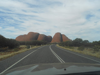
Kata Tjuta - The Olgas

Kata Tjuta - The Olgas, approx 50 km west of Uluru ... Yes that is a sealed road, all the way from here to the Stuart Highway and on to Alice Springs!

Makes these beautiful places accessible to many more people, and we appreciated no more corrugations ... for a while.


Docker River & Lassiter's Cave

Day 3 on Great Central Road & more amazing scenery. Into Docker River for fuel, a quick turn off to view Lassiter's Cave - no one has found his gold reef in all these years! Then on to Kata Tjuta (The Olgas) & Uluru (Ayers Rock).


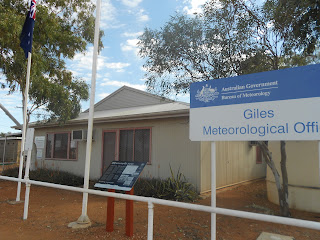
Giles Meteorological Station

Giles Meteorological Station, one of a whole network of meteorological sites all over the world sending up balloons into the jetstream, collecting weather information several times a day.

Very interesting tour of the site and view of the work they do here. Unfortunately no more tours happening after this week, funding & staff cuts! Recording of weather data & scientific work will continue though.