Thursday, 30 August 2012

Mereenie Loop


Mereenie Loop... the "scenic route" from the back of Kings Canyon around and into Alice Springs via Hermannsburg was good, great scenery again, but a pretty rough road in parts. all unsealed 4WD track of course. Finally a good picture of camels! Group of about 6 here.

Good to stop at Hermannsburg & get into Alice... eventually.

Hermannsburg was originally a Lutheran mission settlement, now the indigenous community of Ntaria, 131km from Alice Springs. Albert Namatjira was born here in 1902.

Thursday, 23 August 2012

Kings Canyon 2

Kings Canyon ... views from the top. The sheer rock face is 250metres high and pretty much straight down!

Camped at Kings Canyon Resort then continued on to the Mereenie Loop Road ...  more spectacular country & a rough dirt road, perfect!


Kings Canyon

Kings Canyon, 314km from Uluru, part of Watarrka National Park, and yes all on sealed roads these days.  I first visited here in 1979, bush tracks & no national park then, but the steep climb up to Kings Canyon was there then!

Up the top, weathered sandstone buttressed domes, the "lost city" & the "garden of Eden" to see. 6km walk up, around the rim on both sides of the canyon and back is spectacular.


Mt Conner

100km east of Uluru is Mt Conner, a mesa shaped table topped mountain 3 times larger than Uluru. It is located on Curtain Springs cattle station.

This view is from the lookout on the road to/from Uluru - on one side of the road is the view of Mt Conner in the distance. Cross the road and climb the sand  hill and you get to see this great salt lake.

Flowers & landscape

Uluru ...again

Uluru ... From a distance and close up ... it's huge, majestic & magical.
The National Park is jointly managed by the Anangu Tradional Owners and Parks Australia. The Cultural Centre in the Park gives a great introduction to Anangu culture & the desert environment.


Uluru - Ayers Rock

Uluru - Ayers Rock, 348metres high, the worlds largest sandstone rock. Uluru-Kata Tjuta is a World Heritage listed National Park for its outstanding natural and cultural values.

Lots of people line up to see Uluru at sunset ... so we joined them!


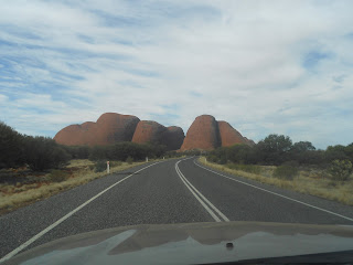
Kata Tjuta - The Olgas

Kata Tjuta - The Olgas, approx 50 km west of Uluru ... Yes that is a sealed road, all the way from here to the Stuart Highway and on to Alice Springs!

Makes these beautiful places accessible to many more people, and we appreciated no more corrugations ... for a while.


Docker River & Lassiter's Cave

Day 3 on Great Central Road & more amazing scenery. Into Docker River for fuel, a quick turn off to view Lassiter's Cave - no one has found his gold reef in all these years! Then on to Kata Tjuta (The Olgas) & Uluru (Ayers Rock).


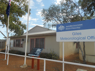
Giles Meteorological Station

Giles Meteorological Station, one of a whole network of meteorological sites all over the world sending up balloons into the jetstream, collecting weather information several times a day.

Very interesting tour of the site and view of the work they do here. Unfortunately no more tours happening after this week, funding & staff cuts! Recording of weather data & scientific work will continue though.


Wednesday, 22 August 2012

To Warburton & Warakurna

Travelled via Warburton, once a mission settlement, & checked out their great local Art Gallery, part of their Council building complex. Couldn't resist another piece of artwork.

Second stop on Great Central Road at Warakurna Roadhouse, just near Warakurna community and Giles Meteorological Station. Roadhouse another  place showcasing local artwork.


Tjukayirla

First stop on Great Central Road.

Stayed at Tjukayirla Roadhouse, decided not to camp and took "backpacker" accom - donga with 2 single beds.

Pleasant camping spot, doesn't feel like you are in the middle of the desert.


Great Central Road

Great Central Road ... and Warbuton is only half way to Alice Springs!

Good dirt road, part of The Outback Way.

The Outback Way unsealed, mostly 4WD & truck route through the Great Victoria & Gibson Desert country.

From Laverton WA, to Warburton, Giles, Docker River, Kata Juta & Uluru, Alice Springs & then the Plenty Highway to Winton in QLD.


Laverton

Laverton, nickel & gold mining area, small town, basic supplies (in three different locations as the supermarket is no longer operating), fuel ... & the friendliest touist information office ever! Great welcome, super friendly staff, coffee!!! and books, souvenirs, permits and an outback display to view and browse your way through. Then on to the Great Central Road up to the Centre ...


Wednesday, 15 August 2012

Gwalia & Leonora

Gold & more Gold, this area has mining in its past as well as in the present. Leonora, 230km north of Kalgoorlie has a wide main street with some older buildings still in use as they were intended, such as the Royal Hotel (no surprise really), and others that have been restored and are now in use in other ways, such as the Library&InformationCentre!  
The township of Gwalia is now an historic site a few kilometres from Leonora, famous for the Sons of Gwalia gold reef discovered in 1896 and mine established in 1898. 
The mine manager at that time was a young 24 year old American mining engineer, Herbert Hoover - later to become the 31st President of the US! Whilst there he designed the angled headframe in the photo, other mine buildings still on the site, and designed and had built the mine managers house, today known as Hoover House. It has been beautifully restored, operates as a B&B, and was where we enjoyed coffee and a snack on the verandah. Lovely! 
    

Meekatharra

Meekatharra, old gold mining town from the past and again now. Plenty of activity with mines and mining in this area.

Arrived at sunset, interesting town, main street, old buildings, 3 hotels, 1 motel ... and all booked out ... except for one basic motel room ... ours! Many vehicles, trucks, road trains & people passing through, mining company personnel, tourists, a busy Monday night in town.

Apparently Meekatharra was first town in Australia to be powered by solar energy. That was in 1982, don't know about 2012.

Area history includes pastoralists, gold mining & the Indigenous people's traditions & rich connection to the land. Interestingly, in the1920's Sir Charles Kingsford Smith & Keith Anderson had a transport business & mail run in these parts, long before their aviation exploits made them famous.

Newman, Pilbara & Iron Ore country

Newman, Iron Ore mining town. BHP Billiton's Mt Whaleback mine is here, the largest single open cut iron ore mine in the world! Mining operations all over here and personnel, mining vehicles, moving  big machinery, make for a busy place.

Karijini National Park

Karijini National Park in the Hammersley Ranges, deep in The Pilbara of WA.  Wittenoom close by as well as Port Hedland, Tom Price, Newman and other huge iron ore and mining ventures.

Karijini scenery and gorges are magnificent - Dales Gorge, Fortescue Falls, Hancock, Kalamina & Joffre gorges amongst others. Deep red stony gorges, red, red soil, amazing spinifex grass, wildflowers. Rocky campsite though!


Camping here became quite interesting on our first night when a Dingo decided to visit our tent site! Howling loudly to its mates across the way. Pretty special.